
The roads they never built across the North Fork

Driving to the end of the Long Island Expressway and exiting onto the western edge of Route 58, Riverhead’s commercial capital, it’s difficult to imagine that a plan once called for the island’s longest road to extend into Southold Town.
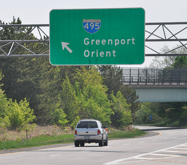
But drawn on a map titled “Expressway Plan 1959 County Planning Board” are two thick red lines that run from the Riverhead Town line to Old North Road in Orient. One line indicates eastbound Long Island Expressway traffic. The other shows traffic lanes heading west.
In this vision of the expressway, Long Island’s major thoroughfare stretched across almost the entire North Fork, running east-west and paved so far north that drivers would have been able to see Long Island Sound at certain points.
When residents from Riverhead to Orient banded together recently to block a plan to send 3,000 more heavy-duty trucks across the North Fork annually via the Cross Sound Ferry, it stood as a reminder of both the limited capacity of our principal roads and how easily that could have changed over the years. So, too, did a recently withdrawn plan to expand the United Riverhead Terminal into a gasoline distribution center, which had the potential to add even more trucks to our roadways.
Scanning through town and county documents, historical society archives and newspaper articles from the past 80 years makes it obvious that the idea of having two bucolic highways to transport motorists across the North Fork was never exactly the plan.
Instead, proposals to expand the expressway, to connect Long Island to New England with a series of bridges and to widen County Route 48 were once the norm for our growing region. Even during the Great Depression there was a road plan for East Marion that would have seen 18 streets built off Main Road, many of them connected by traffic circles. We’ve all heard of the road less traveled, but it’s these roads never built that would have dramatically altered the North Fork.
“It probably would have been the death knell for the region’s rural character,” Bob DeLuca, president of the environmental organization Group for the East End, said of these abandoned proposals. “For all the complaining people do about traffic, the sprawl that accompanies such projects outweighs any short-term traffic benefits.”
From as far back as 1953, when the plan for the Long Island Expressway was first pitched, Riverhead was proposed as the final exit. But almost immediately local officials were calling for an expansion into Southold Town.
While it’s hard to imagine today that anyone in Southold would have supported such a proposal, the supervisor at the time was among its biggest proponents. At an April 1954 meeting of the Suffolk County Board of Supervisors, Southold Town Supervisor Norman Klipp drafted a resolution to build the expressway out to Orient Point, something he said was supported by the entire Town Board.
The resolution, which also included the expansion of Sunrise Highway on the South Fork, was approved by all but the Southampton supervisor. The bill stated that the entire county was “experiencing a remarkable growth and the eastern section is also sharing in the expansion of population and industry.”
![[Click to enlarge] This document, titled 'Expressway Plan 1959 County Planning Board,' can be found on Southold Town's website. It shows the LIE running just south of Goldsmith Inlet. (Credit: Southold Town)](https://suffolktimes.timesreview.com/wp-content/blogs.dir/4/files/TR0514_Roads5_C.jpg)
Even as hope dimmed later that decade, officials in Riverhead and Southold were still calling for an expansion of the LIE to County Route 105, where it could link up to Sound Avenue and North Road.
Riverhead Town Supervisor Robert Vojvoda said in 1966 that the expansion would offer commuters a bypass to avoid the Riverhead traffic circle and prevent “the dumping of expressway traffic onto the already congested east-west Route 58.”
To put this all into perspective now, one has to consider that a half-century ago, Suffolk County was the fastest-growing county in the state, and possibly the nation, and planners thought that more (and wider) roads made sense.
For instance, in 1967, five years before the LIE was extended to its current endpoint at exit 73 in Riverhead, The New York Times said “this agricultural market town, after it is linked with the expressway, may be transformed into the industrial hub of a new Northeast coastal network of air, high-speed rail and highway transportation.”
The same article mentioned a proposal for a cross-Sound bridge between the Riverhead area and Connecticut. On the Long Island side, motorists would have reached the bridge via a short northbound extension of the LIE. The Connecticut terminus of the 19.2-mile bridge would have been Guilford, where they could pick up I-95.
Suffolk County planners and business leaders of that era were eager to establish a direct highway link between eastern Long Island and New England so as to spur development in their then still largely agricultural area. Development pressure in Calverton, where Grumman was operating and a jetport was proposed in the mid-1960s, was also a major factor.
“They argue that [a bridge] would benefit Long Island by opening all of eastern Long Island to industry by connecting two major military electronics production centers [Long Island and the Boston area],” reads a 1964 release from the Regional Plan Association.
Easily the most ambitious plan involved a 25-mile-long chain of bridges from Orient Point linking Plum, Gull and Fishers islands to Watch Hill, R.I.
So breathtaking was the price tag of this island-hopping behemoth (reportedly $635 million in 1971) that even Robert Moses, who seldom saw a highway or bridge proposal he didn’t like, reportedly characterized this one as “impractical.”
Another, more modest bridge plan from the same period, which also bit the dust, was a 9.8-mile $206 million bridge, also served by an LIE extension, that would have connected East Marion with Old Saybrook, Conn. Bridges from Oyster Bay, Riverhead and Brookhaven towns were also proposed but never realized.
Both the proposed Orient Point and East Marion bridges were predicated on the construction of a 13-mile extension of the LIE from Riverhead that would have connected with the North Road (County Route 48) a little west of where its four-lane portion ends at Cox Neck Road in Mattituck.
The state Legislature approved the extension in 1969 but the concept proved unpopular and was deleted from state plans.
If the project had proceeded, “a large number of farms would have been split in half,” recalled Richard Wines, chairman of Riverhead Town’s Landmarks Preservation Commission, “leaving no way to get from one part to the other.”
![[Click to enlarge] A series of 18 roads connected by four main roads extending from a traffic circle was once proposed for East Marion. (Credit: Oysterponds Historical Society)](https://suffolktimes.timesreview.com/wp-content/blogs.dir/4/files/TR0514_Roads4_C.jpg)
At around the same time, a plan was also floated to widen Sound Avenue from two to four lanes through western Mattituck and Northville, bringing that road, long cherished for its pastoral character, into conformity with the widened part of County Route 48.
The old Long Island Lighting Company planned to build nuclear power plants near Sound Avenue in Northville and Jamesport and wanted it widened for easier access to the construction sites, recalled Bill Toedter, president of the North Fork Environmental Council. State designation of the Colonial-era road as a historic corridor in 1975 effectively put an end to the plan.
“The farm community came together and said, ‘We can’t do this,’ ” Mr. Toedter said, adding that the widening “would have taken some of the oldest farmland in the area.”
Of course, the proposed dramatic restructuring of our roadways did not come about in just the past 50 years. East Marion remains a relatively low-key community today, but it surely would have taken a different turn decades earlier if a plan unveiled by Herbert L. Fordham had come to pass. In the Great Depression year of 1934, no less, Mr. Fordham, a lawyer and East Marion resident, rolled out a street plan for the hamlet that makes it look practically as densely packed as Brooklyn.
Running north from Main Road were 18 streets, some leading to a traffic circle with four roads radiating from it. Slicing through the hamlet was a major east-west thoroughfare parallel to Main Road, labeled Express Highway, that would have crossed Dam Pond from a point located in what’s now the beautiful Dam Pond Preserve.
About 50 years later, another east-west thoroughfare north of Main Road was envisioned for Southold Town. While conceived of as a modest town road about 30 feet wide, it would have extended from Orient Point to Mattituck, with a gap or two in between, and run one or two lots back from Long Island Sound, recalled Henry Raynor Jr., who chaired the Southold Town Planning Board in the early 1980s.
“It was usually shown [on town maps] as a strip of land labeled for possible future dedication to the town for the highway,” he said.
The road never materialized, Mr. Raynor explained, because the town revised its zoning regulations so as to create larger lots. “Density was reduced,” he said, “so you wouldn’t have the traffic that was foreseen.”
Today, the aborted road plan is such a distant memory that current Southold Town planning director Heather Lanza was unaware of it until contacted by a reporter; it’s no longer in the town’s master plan.